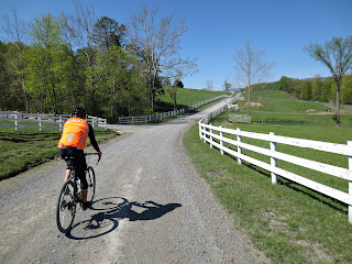
Saint Davids Church Rd, Fort Valley, Virginia
Photo By Peter Beers
Here are some routes centered around the Fort Valley, Virginia area. Fort Valley runs in the middle of Massanutten Mountain. This is a mountainous area with great long climbs and screaming downhills. Awesome gravel roads run through beautiful farm land in the valley. The valley is surrounded on all sides by the George Washington National Forest. Gravel roads climb up into the National Forest for a few ridge line dirt forest roads. This area is great riding but be forewarned, these routes are not for the out of shape rider or those who do not like to climb.
The Gravel Ring (all road) version. Route starts HERE
This route contains a mix of gravel and paved roads. It is approximately 74 miles long with 7400ft of climbing. There are long stretches of Gravel and long stretches of pavement. The first 25 miles is rolling valley roads before you hit the first long gravel climb, Crisman Hollow rd. Which is approx. 7 miles from the bottom to the summit. This is in my opinion is the easiest of the 3 big climbs on this route. Your are rewarded with a nice long screaming downhill. You will then roll on pavement till the next climb, Moreland Gap rd./FR 374. Pretty much all gravel except for a short bit at the beginning. This climb is approx. 6 miles to the summit. Still not the hardest climb on the route. Again you are rewarded with a screaming paved downhill, Edinburg Gap rd. The route then rolls through Edinburg to Woodstock on Rte 11. The Final Big Climb is on Woodstock Tower rd. I hope you saved some energy for this one. It is only 3.5mi. long but is the steepest of the big climbs. Lots switchbacks to fool you into thinking the climb is over. It is gravel with paved turns in the switchbacks. After you summit the climb you have a nice gravel downhill back into the valley. Then you roll about 5 miles back to the starting point. There are 4 water stops on this route. Check the link to the route for locations (they are also on the cue sheet). The first water stop (mile 23.5, Camp Roosevelt picnic area) is only turned on from mid May to late October. There is a close by alternative, Caroline Furnace Lutheran Camp. The Second is a piped spring on Edinburg Rd at about mile 50. The Third is a Sheetz convenience store in Woodstock at about mile 58. The final water stop you will have to go off course at about mile 67 for about 2 miles. It is another piped Spring on FR 66. I suggest you only use this water stop for emergencies, the end of the route is only about 7 miles away.
Moreland Gap/Woodstock Tower Route starts HERE.
This is a shorter version of the Gravel Ring. Basically the same but it is 56 miles long with about 5300ft of climbing. Water stops are in the same places described above (check link and cue sheet for locations). This route has two big climbs on it instead of three. You will climb the east side of Massanutten Mountain on Moreland Gap rd. instead of the west side. The Climb is approximately 6 miles and mainly gravel.The nice thing is you still climb Woodstock Tower Rd in the best painful direction.
More Routes to come, Enjoy!

Do you have the VDOT county road map CD? They ship them out for free.
ReplyDeleteDid this route on Saturday, Sep 26, 2020. Great route! There is a bridge out before the 2nd climb but you can ford the stream. The last climb is INTENSE! Thank you!
ReplyDelete