About This Blog

This Blog contains information on Gravel/Dirt road routes in Virginia , Maryland, Southern Pennsylvania and West Virginia. Also some links to Gravel/Dirt road databases (for planning your own route). Mainly close to the Washington D.C. Metro area. There will not be a lot of new posts. But the posts will be updated regularly. New posts will be added only when there is a new area needed to be added. I hope this will be helpful.

Thursday, August 27, 2020

Short Grinders in Montgomery and South Frederick Counties

                                                West Harris Road, Montgomery County Maryland

 
Here are 3 Shorter Grinders. The first two routes are in Sugarloaf Mountain area. All are good after work or quick rides. The first two start at Monocacy Elementry School. The third Starts at Whites Ferry.

The first, the Sugarloaf Figure 8 

This 18 mile ride around Sugarloaf Mountain takes advantage of most of the gravel roads in the area. It has approximately 8.4 miles of gravel roads and 9.6 of paved roads. Also about 1,200 ft of climbing. The only real climb is on Park Mills rd. It is short but kinda steep, sorta sucks when you are out of shape. The rest of the route is climby but nothing bad. Mt Ephraim rd is a series of short climbs until the peak then a smoking downhill. No need for water stops on this short ride.

The second route Sugarloaf Side Piece 

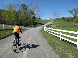
This route runs along the west side of Sugarloaf Mountain to Tuscarora, Md to the C&O canal then back to Monocacy ES. The route is about 22.1 miles with 1,400 ft of climbing. It has approximately 10 miles of gravel roads and 12.1 miles of pavement. Starting from Monocacy ES, the first gravel is W. Harris (pictured Above) and Mt Ephraim Rd about a mile into the ride. This route is an up and down affair for the most part. especially Park Mills rd. The gravel sections are broken into 3 sections. W. Harris/Mt Ephraim rds, Page/Greenfield rds and Nolands Ferrys/C&O canal.  


                                         River Rd, Montgomery County, Maryland

The third route Whites Ferry Figure 8

This easy 20 miler starts at Whites Ferry. It is flattest route I have. Good for an easy spin. It has only 465ft of climbing. Pretty much all on Martinsburg and White's Ferry roads. It has approximately 14.4 miles of unpaved roads with 5.6 of paved roads. This Figure 8 route can be rode in any direction. As described here the route breaks up the C&O sections. Out of the Whites Ferry parking lot head north on the canal for a flat warm up of 4.1 miles. Then turn right off the canal into Dickerson Conservation Park. Then onto Martinsburg Rd. then right onto Whites Ferry rd. This is the only paved section of 5.6 miles back to the canal. Then take the canal to Edwards Ferry. The route then take you back on River rd. Which a nice fairly flat gravel road. 

Enjoy!  

Thursday, June 2, 2016

Due to an injury I have not been doing much gravel grinding lately. But I have been keeping an eye on the database. It seems to be working out fairly well. I wanted to keep my database local to Loudoun but the new site holds more info. It appears everything I had on Google is gone, sorry but that is an Google issue.

Thursday, August 6, 2015

New Loudoun Gravel Road Database plus a lot more

I got tired of trying to fix the database on Google so I am moving all my info to gravelmap.com I will be completing the move over the next few days but most of the roads are there. Plus there appears to be a ton of gravel road info for all over the US. We will see how this works out.

Loudoun Dirtroad Database

Tuesday, July 9, 2013

Great Info

Here is a link to online West Virginia County Maps.The maps show what is suppose to be gravel roads. I am working on another Google Map database from Preston, Monongalia, Tucker and Taylor Counties. http://goo.gl/maps/11Bpp Why a another google database? I find it easier to plan route routes looking at google maps. Why there? My Mother in-law lives near there. It will give me a better excuse to visit. I can't wait to check some of them out.

Here is a link to Charlottesville Bike Clubs website. https://www.cvillebikeclub.org/archive/cbc/maps.htm They have posted up some gravel routes around the Charlottesville area. Maps and Que Sheets, very nice.

Here is the link to the Virginia Dept. of Transportation's county maps. They are not online but they are cheap to buy. 5o cents each or $35 for the whole State. They are a little out of date, some of the roads they say are gravel are actually paved now. All the better reason to have a google map database for accuracy.VDOT County Maps

Enjoy!

Monday, June 17, 2013

Wythe/Bland/Smyth Counties, Virginia. Gravel Road Database


This Database is near and dear to me. For most of you DC folks, it is not near. But if you ever find your way down to one of the most beautiful areas I have rode, you should check it out.

This database is a work in progress with a bunch of new colors for roads (for those who are familiar with my other Databases). I am putting the info out earlier then usual. I began using VDOT's county roads maps to help with discovering new gravel roads. I have found that the maps are chock full of mistakes. The roads may have been paved since the maps were published. So on roads I have never been on or can't remember being on, I am using google earth to help identify possible gravel roads. I have found a need to code them so people know they are not confirmed gravel roads.

Basically the color codes go like this:

Brown = Confirmed Gravel/Dirt by myself or other
Blue    = Unconfirmed but VDOT says it is gravel and looking at Google Earth, it appears to be. In   other words it is a good bet it is gravel.
Purple   = VDOT say it is, can't tell on Google Earth.
Red       = VDOT says it is, but is most likely paved
Green    = Forest or Logging Road (Adventure Time!)

I hope this helps and check back often. The roads will either be brown or removed. I ride there as often as I can.


Wednesday, May 8, 2013

Fort Valley Area, Massanutten Mtn., Shenandoah County, Virginia

Saint Davids Church Rd, Fort Valley, Virginia
Photo By Peter Beers

Here are some routes centered around the Fort Valley, Virginia area. Fort Valley runs in the middle of Massanutten Mountain. This is a mountainous area with great long climbs and screaming downhills. Awesome gravel roads run through beautiful farm land in the valley. The valley is surrounded on all sides by the George Washington National Forest. Gravel roads climb up into the National Forest for a few ridge line dirt forest roads. This area is great riding but be forewarned, these routes are not for the out of shape rider or those who do not like to climb.

The Gravel Ring (all road) version. Route starts HERE
This route contains a mix of gravel and paved roads. It is approximately 74 miles long with 7400ft of climbing. There are long stretches of Gravel and long stretches of pavement. The first 25 miles is rolling valley roads before you hit the first long gravel climb, Crisman Hollow rd. Which is approx. 7 miles from the bottom to the summit. This is in my opinion is the easiest of the 3 big climbs on this route. Your are rewarded with a nice long screaming downhill. You will then roll on pavement till the next climb, Moreland Gap rd./FR 374. Pretty much all gravel except for a short bit at the beginning. This climb is approx. 6 miles to the summit. Still not the hardest climb on the route. Again you are rewarded with a screaming paved downhill, Edinburg Gap rd. The route then rolls through Edinburg to Woodstock on Rte 11. The Final Big Climb is on Woodstock Tower rd. I hope you saved some energy for this one. It is only 3.5mi. long but is the steepest of the big climbs. Lots switchbacks to fool you into thinking the climb is over. It is gravel with paved turns in the switchbacks. After you summit the climb you have a nice gravel downhill back into the valley. Then you roll about 5 miles back to the starting point. There are 4 water stops on this route. Check the link to the route for locations (they are also on the cue sheet). The first water stop (mile 23.5, Camp Roosevelt picnic area) is only turned on from mid May to late October. There is a close by alternative, Caroline Furnace Lutheran Camp. The Second is a piped spring on Edinburg Rd at about mile 50. The Third is a Sheetz convenience store in Woodstock at about mile 58. The final water stop you will have to go off course at about mile 67 for about 2 miles. It is another piped Spring on FR 66. I suggest you only use this water stop for emergencies, the end of the route is only about 7 miles away.

Moreland Gap/Woodstock Tower Route starts HERE.
This is a shorter version of the Gravel Ring. Basically the same but it is 56 miles long with about 5300ft of climbing. Water stops are in the same places described  above (check link and cue sheet for locations). This route has two big climbs on it instead of three. You will climb the east side of Massanutten Mountain on Moreland Gap rd. instead of the west side. The Climb is approximately 6 miles and mainly gravel.The nice thing is you still climb Woodstock Tower Rd in the best painful direction.

More Routes to come, Enjoy!

Tuesday, April 30, 2013

Michaux State Forest Gravel Road Database


Here is a link to a database map of the gravel, dirt and some double track roads in Michaux State Forest, Pennsylvania. It is being compiled with help from Brett Weiser (Friend and Michaux Native). Not 100% complete as no map of mine ever will be. I will update it when needed. But you can put some nice routes together as is.

Enjoy!